Adaptive Environmental Solutions

512-262-7538
Arroyo Environmental ConsultantsArroyo Environmental Consultants
Arroyo Environmental Consultants
Adaptive Environmental Solutions
  • Home
  • Fishing Tournament
    • 2018 Arroyo Fishing Tournament Results
  • Services
    • Biological
    • Endangered Species
    • Environmental Permitting
    • Land Management
    • Phase I and Phase II Environmental Site Assessments (ESA)
    • Pond and Lake Design
    • Scientific Studies
    • Surveying – GIS
    • Water Quality Monitoring
    • Wetland Delineation
  • Our Team
  • Locations
    • Austin
    • Beaumont
    • Corpus Christi
    • San Antonio
  • Projects
  • Blog
  • Employment Opportunities
  • Contact Us
Menu back  

Surveying – GIS

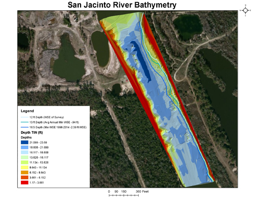
Hydrographic Surveying

Arroyo staff have successfully completed small scale hydrographic surveys for ponds and small lakes (<200 acres) as wells as large reservoirs such as Wright Patman Lake and Lake Wichita. Arroyo’s senior scientists worked for the Texas Water Development Board Instream Flows and Hydrographic Survey teams and successfully surveyed one coastal bay, 27 lakes (volumetric and sedimentation) and over 400 miles of rivers in Texas.

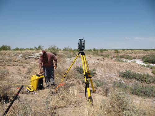
The Arroyo team utilizes a fleet of survey boats adapted to various environments and various acoustic current profilers, multibeam echosounders and other such surveying equipment to successfully collect the most accurate data possible. In addition, Arroyo staff have helped develop advanced data processing methodologies to ensure the highest quality data.

Water Quality Monitoring Austin

Wetland Delineation Austin

Topographic Surveying

Topographic surveying is an important tool utilized in many types of environmental studies such as wetland delineations, fisheries assessments, water quality modeling, hydrodynamic modeling, hydraulic modeling, etc. Arroyo staff continue to stay on the cutting edge of technology by incorporating traditional surveying techniques with advanced surveying technology. Arroyo staff have excelled for years in utilizing robotic scanners, total stations and GPS units.

Construction Stakeout

Arroyo staff have successfully completed various construction stakeout projects including those for landscape lighting, solar panel farms and tree surveys.

GIS

A Geographic Information System (GIS) allows a user to store, manipulate, analyze, manage, and present all types of spatial or geographical data. GIS is an essential tool for scientists, planners, managers and others and is used in a variety of disciplines, whether it is for intensive data analysis or the creation of a map. Arroyo staff are experienced with different GIS software packages and can provide effective and professional GIS services.


Arroyo Environmental Consultants
161 Cushman Dr. | Kyle, TX 78640
512-262-7538


HUB Certified
  • Home
  • Fishing Tournament
  • Services
  • Our Team
  • Projects
  • Blog
  • Contact Us
Recent Posts
  • Tough fishing at the final tournament of the season
    September 30, 2018
  • The standings are in after the August 25th Arroyo Fishing Tournament!
    August 27, 2018
  • The Countdown to the August 25th Tournament begins…
    August 15, 2018
  • Bass was King at the July 28th Arroyo Fishing Tournament
    August 9, 2018
  • The BIG fish hid well at the June 30th tournament
    July 2, 2018
  • The June 2nd Fish-Off!
    June 4, 2018
Arroyo Environmental Consultants © 2018 | Website by Josiesque Designs